RespondAR is a UAV Pilot Application designed to provide geographic augmented reality overlays on live video. This provides enhanced situational awareness to Pilots in Command, Camera Operators, Incident Commanders and other mission viewers.
RespondAR is designed for use by a variety of Emergency Response Personnel, including: Fire Departments, Police Departments, State and Federal Emergency Response Teams and others. The app allows First Responders to maintain situational awareness with industry-leading, GIS-based, augmented reality on real-time, full motion video captured by unmanned aircraft systems.
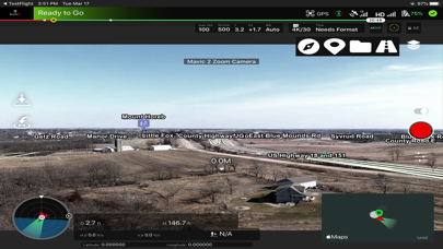
The RespondAR app utilizes industry-leading situational awareness technology and provides GIS information including road vectors, street names, points of interest and other map entities as augmented reality overlays on live airborne video.
The RespondAR app is specifically designed with First Responders in mind. The developers of RespondAR have over two decades of experience in the unmanned aircraft systems industry supporting both small and large UAS.
RespondAR is currently compatible with DJI hardware, giving pilots familiar features including: Auto Take-Off and Auto-Land, multiple FPV modes, full camera control and Return to Home, making flying simple and easy.
► FREE FEATURES
• NO ADS
• DJI-Compatible Flight Application
• Control Overlay Aesthetic with Offset Sliders
• Turn Point of Interest Overlays On/Off
► BASIC FEATURES
• NO ADS
• DJI-Compatible Flight Application
• Control Overlay Aesthetic with Offset Sliders
• Turn Point of Interest Overlays On/Off
• Turn Street Vectors On/Off
• Display Street Names
► PRO FEATURES
• NO ADS
• DJI-Compatible Flight Application
• Control Overlay Aesthetic with Offset Sliders
• Turn Point of Interest Overlays On/Off
• Turn Street Vectors On/Off
• Turn Street Symbols On/Off
• Display Street Names
• Street Name Label Style Tilt Adjustment
• Street Name Label Density Control
• POI Overlay Transparency Control
• Street Vector Transparency Control
• Street Name Transparency Control
• Pre-Cache Map Data (Allowing for Offline Use)
• Geocoding (Touch Screen and Receive Physical Address)
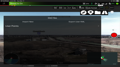
• Drop User Points into Video and receive Lat/Long Geocoordinate
• Name User Points
• Turn User Points On/Off
• Location Sharing
• Custom KMZ Import
► FEEDBACK
Have an issue? Want to request a new feature? Want to see a tutorial video? Asking a question?
Feel free to check out our website, www.rapidimagingtech.com/respondar or contact us directly at
[email protected].
► TERMS OF USE
Link to Terms of Use: https://www.rapidimagingtech.com/respondar-terms-of-use/
 AppGhost.com