 AppGhost.com

iGlide lite
Navigation • Updated 2 years ago
Download from App Store Like ()Version 2.9.1 • Requires iOS 12.0 or newer
Created by:
Garrecht Avionik GmbH
Change-Log
-
🔃 Updated to v2.9.0
2 years ago
-
🔃 Updated to v2.8.3
2 years ago
-
🔃 Updated to v2.8.2
2 years ago
-
🔃 Updated to v2.8.1
3 years ago
-
🔃 Updated to v2.7.1
4 years ago
-
🔃 Updated to v2.7
4 years ago
-
🔃 Updated to v2.6
7 years ago
iGlide - the Soaring Navigation Software by AIR Avionics
iGlide is a soaring navigation App with advanced functionality that is amazingly easy to use. iGlide supports glider pilots during a competition, a cross-country flight, or just during short recreational flights.
iGlide comes in three editions at three price-points. Starting with "iGlide lite" and "iGlide advanced" up to "iGlide pro". All apps can be upgraded later-on by paying the price difference in an in-app-purchase.
Features of iGlide lite:
- Simple and easy to use Direct-To function to a single waypoint.
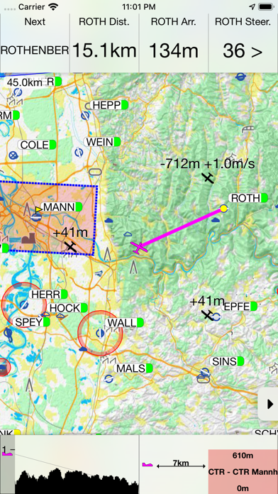
- Easy to read, high-resolution terrain map with detailed topographical features.
- Free daily updates for aviation data such as airspaces, airfields, and navaids.
- Final glide calculator with Ballast, Bugs, MacCready, and aircraft polar data.
- Profile view showing terrain and airspace en route.
- Vertical airspace overview and airspace warnings
- Free airport and airspace-database with free updates
- Additional data can be purchased as in-app-purchase
- Flight-statistics with logbook
- Traffic is displayed on the map if an appropriate data source is connected (FLARM, AIR TRAFFIC or similar).
- Visual and voice traffic warnings, if an appropriate data source is connected.
- Many display options individually configurable.
- Flight-logging (IGC and KML format).
- Live tracking on different servers (e.g. livetrack24.com).
- Track-Line showing the preceding flightpath on the map.
- Data import for all common data formats (CUP/DAT/OpenAir/PLR etc.)
- Live METAR weather data for selected airports.
Additional features in iGlide advanced:
- Route planning over any number of waypoints.
- Directly upload flight logs to OLC (www.onlinecontest.org) or send via eMail.
- Rubberband function for quick and easy route manipulation.
- Accurate wind calculation.
Additional features in iGlide pro:
- Calculation and optimization of the current OLC scoring distance.
- Extensive route planning with turn areas, assigned areas and implementation of FAI Rules (e.g. finish circle).
- FAI triangle optimization.
- Comprehensive in-flight statistics functions.
- Final glide calculation over terrain.
- Live and super-easy AAT optimization.
- Thermal Climb Optimizer.
IMPORTANT SYSTEM REQUIREMENTS: iOS 12 or newer. Devices running older versions are not supported.
iGlide is a soaring navigation App with advanced functionality that is amazingly easy to use. iGlide supports glider pilots during a competition, a cross-country flight, or just during short recreational flights.
iGlide comes in three editions at three price-points. Starting with "iGlide lite" and "iGlide advanced" up to "iGlide pro". All apps can be upgraded later-on by paying the price difference in an in-app-purchase.
Features of iGlide lite:
- Simple and easy to use Direct-To function to a single waypoint.
- Easy to read, high-resolution terrain map with detailed topographical features.
- Free daily updates for aviation data such as airspaces, airfields, and navaids.
- Final glide calculator with Ballast, Bugs, MacCready, and aircraft polar data.
- Profile view showing terrain and airspace en route.
- Vertical airspace overview and airspace warnings
- Free airport and airspace-database with free updates
- Additional data can be purchased as in-app-purchase
- Flight-statistics with logbook
- Traffic is displayed on the map if an appropriate data source is connected (FLARM, AIR TRAFFIC or similar).
- Visual and voice traffic warnings, if an appropriate data source is connected.
- Many display options individually configurable.
- Flight-logging (IGC and KML format).
- Live tracking on different servers (e.g. livetrack24.com).
- Track-Line showing the preceding flightpath on the map.
- Data import for all common data formats (CUP/DAT/OpenAir/PLR etc.)
- Live METAR weather data for selected airports.
Additional features in iGlide advanced:
- Route planning over any number of waypoints.
- Directly upload flight logs to OLC (www.onlinecontest.org) or send via eMail.
- Rubberband function for quick and easy route manipulation.
- Accurate wind calculation.
Additional features in iGlide pro:
- Calculation and optimization of the current OLC scoring distance.
- Extensive route planning with turn areas, assigned areas and implementation of FAI Rules (e.g. finish circle).
- FAI triangle optimization.
- Comprehensive in-flight statistics functions.
- Final glide calculation over terrain.
- Live and super-easy AAT optimization.
- Thermal Climb Optimizer.
IMPORTANT SYSTEM REQUIREMENTS: iOS 12 or newer. Devices running older versions are not supported.
Changelog
New in this version
2.9.1:- Fix for duplicate entries in Airport/Waypoint list in some cases
- Fix for dark menus in some screens, while not using Dark Mode
- Fix for enabling/disabling active Countries in some cases
- Other bug-fixes and improvements
2.9.0:
- Background support: The app now continues functioning while in the background. This means you can switch apps during flight, while logging will continue. It will also continue with the device locked (screen off).
- New onboarding process, improving the initial setup experience.
Videos about this app
Warning: Invalid argument supplied for foreach() in /data/wwwroot/appghost.com/show.php on line 413